Landform and regolith in the Tenkoto area (Eastern Senegal)

Share

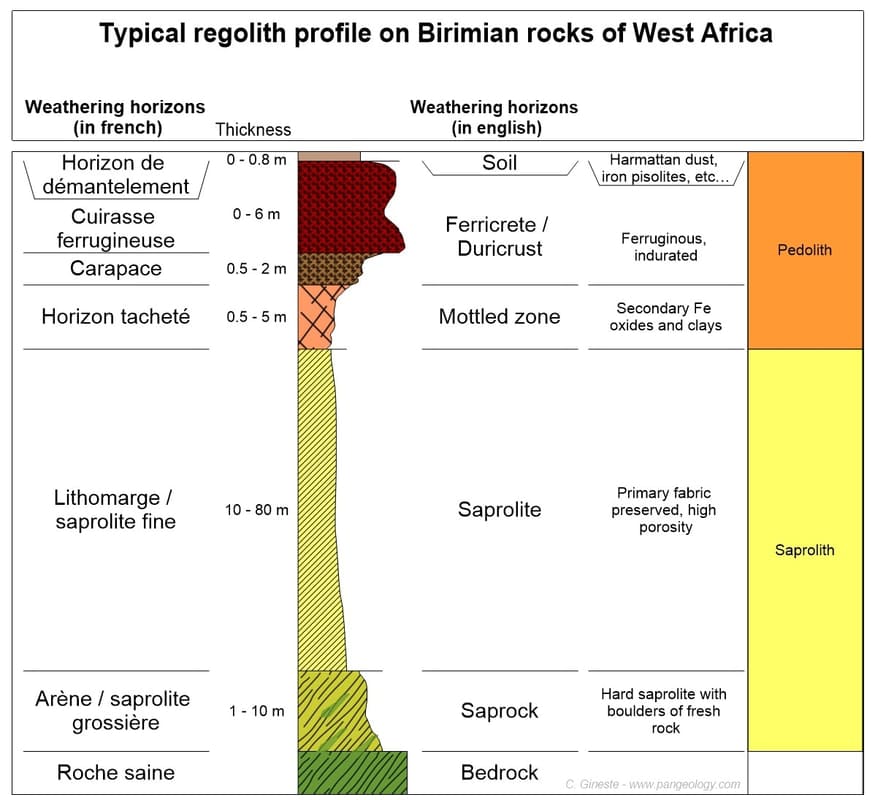
The weathering profile developed on the Birimian rocks of West Africa is, or looks, relatively simple. But its genesis is not. A few years ago, within a research team of IRD, I worked in the Tenkoto area (Senegal), already studied by P. Michel in the 60’s and 70’s and very adapted to examine the filiation of the ferricrete.

In the 1960s and 1970s, several BRGM and ORSTOM researchers were interested by the weathering profiles capped with a ferruginous duricrust (aka ferricrete or cuirasse in French), particularly in Senegal. Two schools of thought confronted each other on how the weathering profile was formed.
 
The autochtonist school (residual ferricrete)    
Nahon, Pion and Leprun studied the weathering processes on a geochemical scale and see the profile as a logical succession of alteration that gradually deepens. They consider ferricrete as the ultimate stage of rock weathering.

The allochtonist school (transported ferricrete)
To these three authors, who envisage the autochthony of ferricrete, is opposed the vision of the geomorphologists Michel, Grandin, and Boulet, who studied ferricretes on a much larger spatial and temporal scale. Indeed, they distinguish the residual bauxitic duricrust of the old African Surface from the younger ferricretes which, according to them, largely correspond to the cementing of detrital material and the remobilisation of iron from the overlying duricrusts in the landform.

To put everyone in agreement, it would seem from our experience that both cases of residual or transported ferricrete can be found in West Africa – even if they are mostly transported.

Let’s look at a typical case of a transported ferricrete following the footsteps of P. Michel who studied the geomorphology of Eastern Senegal and particularly the Tenkoto area (where I worked in 1999-2000).

Journal

Latest articles from Mineralogique

The Mérétrice mine, New-Caledonia

The former lead-zinc-silver mine at Mérétrice was a small operation that was active intermittently between 1884 and 1930 in the far north of New Caledonia.

Mineralogique Blog

Somewhere in West Africa, while conducting reconnaissance on a remote site where a major gold rush took place in 2014, I found a sample that was unexpected in the context of the gold deposits in the sub-region. At this site, while most of the artisanal miners focused on saprolite, some miners followed the mineralisation down to the bedrock, which consisted of very hard quartzite on the edge of a granitic intrusion. Artisanal mines in fresh rock are relatively rare given the challenges of digging at these depths; only very high grades could justify such work.
A few years ago, road works between Ndende and Tchibanga uncovered beautiful sections of Gabon's distinctive weathering profile. We used the opportunity to sample the saprolite in order to obtain valuable geochemical information. The yellowish layer at the top of the embankment is the Cover Horizon, which is actually wind-blown silt (loess) from southern Africa, deposited around 35,000 years ago. It varies in thickness from 1 to 4 metres and is found almost everywhere in Gabon. It covers much of the bedrock, but is currently being eroded.
During a field trip in South Africa, I visited the famous Blue Mine in Springbok. This old mine is part of the O’Okiep copper district located in the Namaqualand Metamorphic Complex. The Blue Mine is historically significant as it is considered as the first ‘mining operation’ in South Africa. The mineralised outcrops have been mined by the native people of Namaqualand long before the arrival of European, but industrial mining started only in 1852 with this very mine.